
Wrangell-St. Elias National Park is the largest national park in the United States. Over 13 million acres of snowcapped mountains, glaciers, rivers and lakes are practically impenetrable by automobile. And what is accessible by car or truck consists of two unpaved roads along the outer fringes with one-lane bridges and narrow passages.
Our first view of Wrangell-St. Elias was the mountains in the distance as we crossed the border into Alaska on the Alaska Highway. From the Tetlin National Wildlife Refuge and from Lakeview Campground, we saw a glimpse of the beauty we were expecting during our roadtrip.
Our next view was at the Visitor Center on Richardson Highway (the road to Valdez). The Visitor Center is on the most western edge of the national park. Views from here were hazy and relatively nondescript, but the Visitor Center was informative with a few short trails around it to explore.
After we left Valdez, we found a boondocking spot in Kenny Lake, a small farming community on the Edgerton Highway (Route 10) which ends in Chitina where McCarthy Road—one of the two unpaved roads in the national park—begins. Even though there is a campground at the end of McCarthy Road (with a couple of others along the way), we did not want to take the Airstream down it. It is 60 miles long, running along the southern portion of Wrangell-St. Elias NP. We had already heard a couple instances this summer of motorhomes sliding off the soft shoulders when they got too close to the edge. We aren’t sure how that happened because, even though the road is narrow in some spots, there is very little traffic on it. In fact, about 30 vehicles passed us as we drove the entire length going in with less than that passing us as we drove out.
We left our Airstream at the boondocking spot to spend the day driving to and exploring McCarthy and Kennecott Mines. We were entertained with scenic river views to the south with interspersed mountain and lake views to our north, the one-lane Kuskulana Bridge as we crossed the same-named river with a glacier as its origin, and the now-unused and dilapidated Gilahina Train Trestle (in operation just for the Kennecott Copper Mines from 1911-1938). The trestle was built in just 8 days!
At the end of McCarthy Road was the Kennicott River, a campground, and plenty of parking for those who travel down to this area. A pedestrian bridge provides access across the river to get to McCarthy (about 1 mile away) and Kennecott (5 miles further). There is also a private bridge further down the river for some vehicle traffic, but the owner charges anyone who wants to cross it (with steep prices). It is not open for tourist traffic from what we understand.
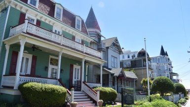
McCarthy is a cute little tourist town with a year-round population of about 30, growing to a few hundred during the summer for the tourist season. It has kept its rustic feel, with antique cars located around the area, old structures remodeled for lodging and restaurants, and a museum in the old train depot. Many flock here for hiking, biking, rafting, and flightseeing (yes… there is a small airport!).
Kennecott Copper Mines, now part national historic site and part privately owned, is five miles further into the national park. How someone found copper in this remote region and developed a robust mining operation around it is mind-boggling to me. Kennecott Copper Mines had its own power plant (because… location in the middle of nowhere!), post office, general store, school, and housing. Transporting copper out of the area was by rail. Massive infrastructure was built for a mining operation that lasted less than 30 years.
The railroad hasn’t operated in that area since 1938, so the tracks have deteriorated, and trestles have crumbled. As a tourist, getting to the historic site from McCarthy requires a van ride. We tried riding our e-bikes, but they were not the right type for unpaved roads (plus it is mostly uphill for five miles!). We discovered two shuttle van options: one was $5 per person one way from the pedestrian bridge to Kennecott; the other was a free van ride that wasn’t advertised and was on a trial run for the summer of 2023. Carl learned about it from a museum volunteer. It ran every half hour between McCarthy and Kennecott.
Beyond Kennecott Copper Mines are hiking trails to Root Glacier. When we go back, our plan is to hike to Root Glacier and hang out in McCarthy. We ate at The Potato and were waited on by someone who has been coming to McCarthy in the summer for the past decade. She and her partner, along with a couple of other friends, recently bought a large piece of land on Long Lake (a long lake we passed on McCarthy Road), and they plan to build a house to settle there during the summer and travel the rest of the year.
The other unpaved road into the northern portion of Wrangell-St. Elias is Nabesna Road (42 miles long). It begins in Slana, which is on the Tok Cutoff Glenn Highway. We did not get to this road, but we will plan to drive it next time!
The day trip to McCarthy and Kennecott Mines was charming and informative and, for us, will be well worth a longer stay in the future.
Watch our short pictorial video of McCarthy Road and Kennecott Mines (above or at https://youtu.be/5-_saYoqTDs).
For previous installments of our Alaska Roadtrip:
10) Kenai Peninsula … Alaska’s Summer Playground
9) Bear Encounter at the Confluence
7) Catching Up … Parts of “Interior” Alaska
6) Denali National Park and a Peek at its Peak!
5) Driving the Dalton to the Arctic Circle
4) Summer Dog Mushing experience Iditarod racers Jeff and KattiJo Deeter of Black Spruce Dog Sledding
2) Banff National Park, the Icefields Parkway, and Jasper National Park
1) Alaska Roadtrip Installment 1 (Theodore Roosevelt National Park and more!)
Leave a reply